Hudson Bay Region Photos.
All summer scenic photos were taken between 7/13/96 and 7/23/96 during my stay at the Churchill Northern Studies Centre, located in the Cape Churchill Wildlife Management Area, apx. 17 miles S. of Churchill, Manitoba, Canada. The only paved road runs between the town of Churchill and the CNSC, where it ends. A gravel extension of that road heads north where it ends at Cape Merry, a provincial park that includes an historical 18th century fort. The rocky shoreline is a favorite landing area for polar bears. Gravel roads, all connected to the main road, offer alternate pathways to wilderness attractions.
If you aren't interested in going further, return to Snow fruits article. These should load fairly quickly since I redid them as low-qual jpegs.
- View of a Hudson Bay sand dune on a sunshiny day. Note how the tangled woody, proably dead exposed roots add some stability to this dune. I don't know if these roots are from earlier growths of Dryas integrifolia, or from some other species that failed to survive the winds and shifting sands. Note the orange lichen on the exposed rock (far right of the main dune). Actually another view of the photo above.
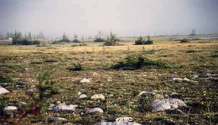
- At the Northern Treeline Responding to wind abrasion, long, cold winters and permafrost, the trees become stunted and widely spaced as the boreal forest makes its last stand before advancing tundra. This photo was taken in light fog, apx. 2 miles inland from Hudson Bay's coastline.
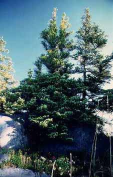
- Hidden boreal meadow completely invisible from the road. A huge boulder formation faces the road near a man-made landmark known locally as "twin golfballs." If you fight your way thru the willow and birch shrub thicket and all the mosquitoes and biting flies and climb the rocks, you come upon an exquisite meadow of low-growing plants (mostly bearberry and Arctic Dryas) lined by trees that, thanks to their sheltered location among these rocks, are able to grow taller, with better form than many in the area.
- a detail from that same hidden meadow near "twin golfballs. The white flowers are Arctic dryas, the pink ones are either wild sweet pea (Hedysarum mackenzii) or Raups Indian Paintbrush (Castilleja raupii), or both. The casual viewer would never guess how fierce the biting flies and mosquitoes can be in this apparently idyllic place. However, they feed many species and pollenate at least one species of orchid.
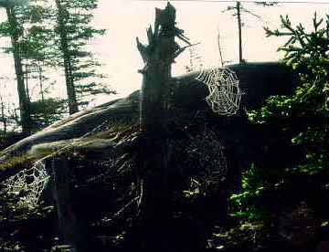
This may be a bit MUCH, but I really got off on the spider webs!
- Spider Webs In a darker corner of this same hidden meadow I found trees living and dead, draped with spider webs. These are among the many species that feed on the region's abundant insect life. In this relatively small area can be counted at least four large spider webs.
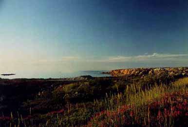
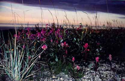
- Sunset overlooking a rocky shoreline, taken from the road leading from Churchill to the Northern Studies Centre.
- Shoreline vegetation includes Wild Sweet Pea (Hedytsarum mackenzii), Castilleja raupii and misc. grasses. In some parts along and near the shore, glacial moraine has created a surface of natural gravel. This is actually a detail of the photo above.
- Typical bog Due to the area's intermittant permafrost, drainage is poor. Sprinkled among the spagnum moss-covered tundra lands are bogs, ponds and lakes. All this standing water supports the life cycle of the region's many species of mosquitoes.
- Tree Island over looking a grass-filled pond near an esker.
- Flowers at Fort Prince of Wales Provincial Park
Fort Prince of Wales is an 18th century fort on an island in the middle of Hudson Bay.
Since it also happens to be a popular landing point for polar bears, visitors are strongly advised to be accompanied by Parks Canada guides, all of whom carry guns and inspect the island before their guests are allowed to walk past the landing area.
Polar Bears at LAST. All taken 11/94
I can be reached by email at alice.ramirez@anderson.ucla.edu
Go to Alice's Homepage